
 |
MapGeo | Quarterly NewsletterSepetemer 2026 |
_____________________________________________________________________________________________________________________
This Quarter's MapGeo Community Spotlight |
 |
Old Lyme is a historic coastal town in New London County, Connecticut |
Nestled at the mouth of the Connecticut River where it meets Long Island Sound, Old Lyme, CT is a community defined by both its natural beauty and its rich New England heritage. Old Lyme played an important role in Connecticut’s maritime history, with fishing, shipbuilding, and coastal trade serving as early economic drivers. Expansive salt marshes, scenic river views, and miles of coastline create a landscape that is both ecologically significant and visually inspiring. Today the town continues to balance historic preservation, environmental stewardship, and a deep appreciation for the waterways that have defined its character from the beginning.
In addition to its rich history and remarkable natural setting, Old Lyme leverages modern GIS through MapGeo to provide residents, staff, and visitors with easy access to critical community information. Given Old Lyme’s unique location along both the Connecticut River and Long Island Sound, environmental awareness is an important component of municipal planning and land management. Through MapGeo, users can explore a variety of GIS layers that help illustrate the relationship between properties and the surrounding environment, including flood zones, conservation areas, wetlands, coastal boundaries, and other regulatory datasets. These mapping resources provide valuable context for development, permitting, emergency preparedness, and natural resource protection, helping the Town balance responsible growth with the preservation of the coastal and riverine landscapes that have shaped Old Lyme’s character for centuries. By making this information readily available, Old Lyme enhances transparency, supports informed decision-making, and improves access to municipal data for property owners, developers, real estate professionals, and local officials. |
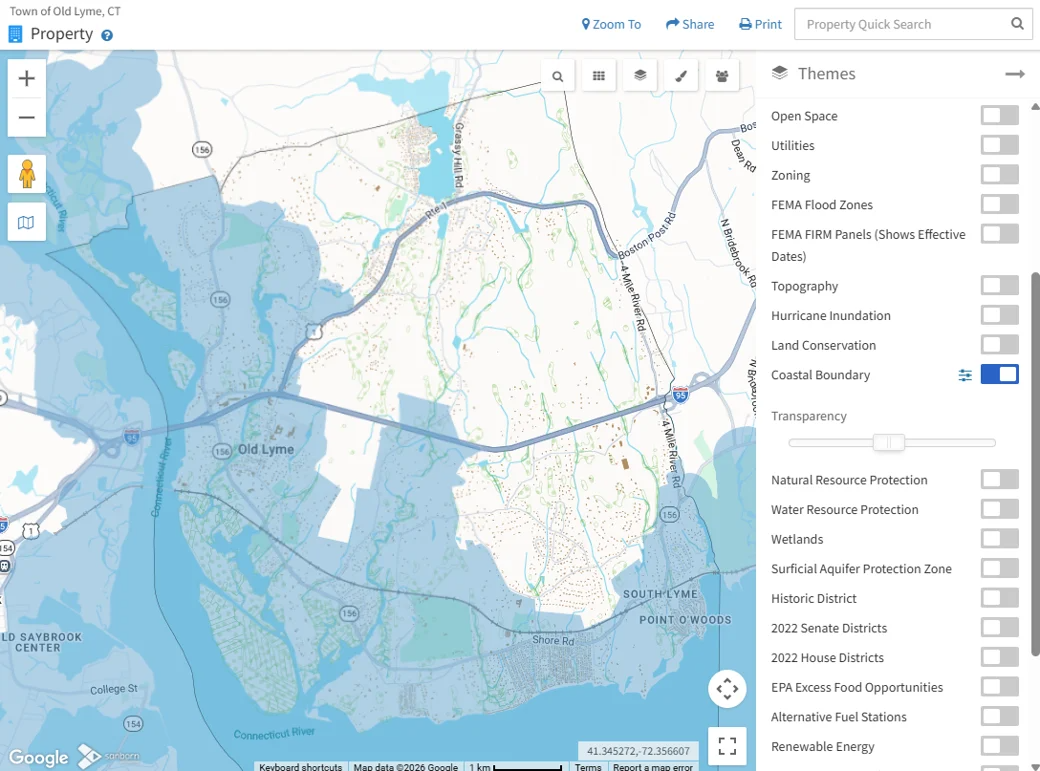 |
Figure 1: Old Lyme's MapGeo displaying the Coastal Boundary layer |
|
Achieving a 1:1 Match Between GIS Parcels and CAMA Records |
Over the summer, Sanborn Geospatial partnered with several Connecticut municipalities to improve the alignment between GIS parcel data and assessor records maintained in Computer-Assisted Mass Appraisal (CAMA) systems. A key part of this effort involved creating a one-to-one relationship between GIS parcels and CAMA records by separating individual condominium units into their own parcel features.
Historically, many municipalities relied on intersection tables to connect a single condominium parcel in GIS to multiple ownership records in CAMA. By representing each condo unit as its own parcel, those intersection tables are no longer necessary, simplifying data management and improving data integrity.
For communities like Old Lyme, a MapGeo customer, this enhancement also delivers a better user experience. Residents and staff can now search for and navigate directly to a specific condominium unit rather than being directed to the general condominium parcel, making property information easier to find and access. |
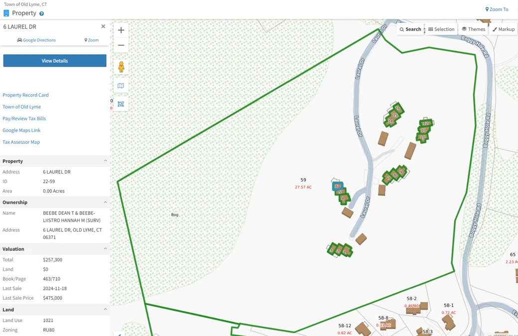 |
Figure 2: Town of Old Lyme, CT MapGeo individual condo units |
|
Spatial IQ Webinar - Building a Master Address Table |
Join Sanborn Geospatial for an informative webinar exploring how organizations can develop a Master Address Table (MAT), an authoritative repository that unifies address information from multiple sources into a standardized, reliable, and maintainable dataset. Municipal clients have successfully used MATs to integrate permitting platforms, improve data quality, and streamline workflows.
During this session, we'll discuss:
Whether you are a GIS professional, assessor, planner, permit administrator, or IT leader, this webinar will provide practical insights into creating and maintaining an address framework that improves data quality, supports municipal operations, and serves as a trusted source for the entire organization. Save the Date: Thursday, September 24, 1:00 PM EDT Registration Link: Register here for the webinar |
|
Spatial IQ for MapGeo Annual Overlay |
Sanborn Geospatial is excited to announce that you now have a new insightful public overlay map theme on your MapGeo website! This new overlay is just one part of your Spatial IQ™ for MapGeo Managed Services program benefits. This year’s overlay theme is broadband serviceable locations and their service status according to the Federal Communications Commission (FCC). Locations are aggregated to the hexes (resolution 8 H3 hexes are about .28 square miles in area) to allow a granular look at where there is and isn’t reliable broadband service. Per the FCC, a “served” location can get mass-market broadband service equal to or better than 100 Mbps download, 20 Mbps upload. |
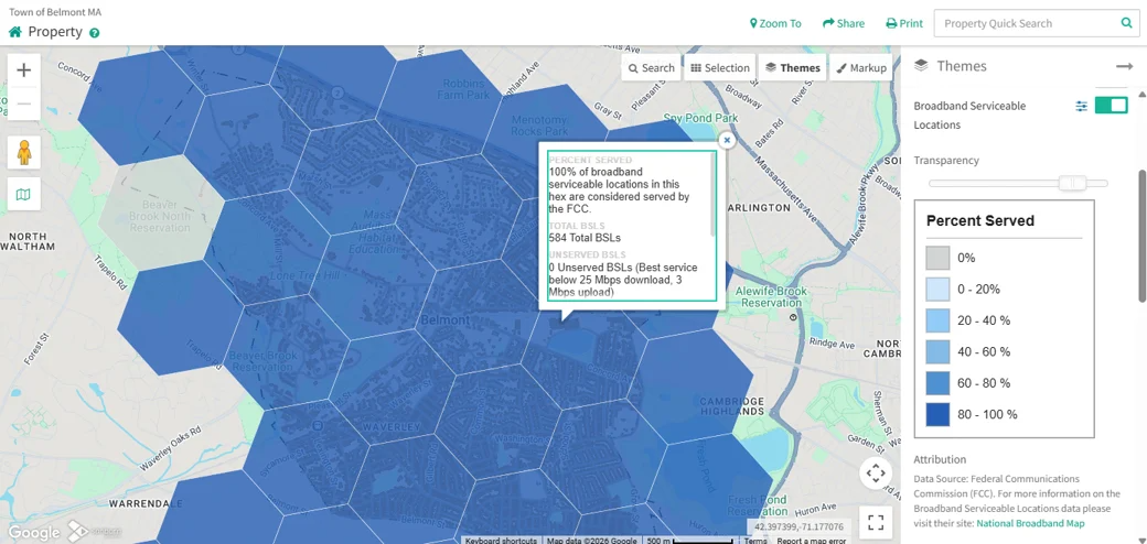 |
Figure 3: FCC Broadband Serviceable Location hex layer shown on Belmont, MA's MapGeo site |
If you are not part of the Spatial IQ program that received this theme but are interested in adding this data to your MapGeo please reach out to MapGeo Support for details. |
|
SIQ Strategic Reminder |
For Spatial IQ customers, with the new fiscal year here, it is time to schedule your annual strategic planning meeting. Meet with your project manager to review action items discussed last year and set up a game plan to grow your GIS program for the year ahead. |
|
Listening, Learning, and Growing with Our Customers |
At Sanborn Geospatial, our relationships with customers extend far beyond implementation and support. As part of our ongoing customer engagement efforts, we are reaching out to MapGeo customers to better understand their evolving goals, challenges, and priorities. These conversations are an opportunity for us to listen. Municipalities are continuously adapting to new technologies, changing workflows, and increasing demands for data accessibility. By engaging directly with our customers, we gain valuable insight into how they are using MapGeo today and where additional tools, products, and services can help them achieve even greater success.
Whether it's enhancing public access to information, streamlining internal operations, improving data quality, leveraging new GIS capabilities, or exploring solutions from other Sanborn business units, our goal is to ensure customers are aware of the resources available to support their needs. These discussions help us identify opportunities to provide additional value through products such as Spatial IQ, Broadband Navigator, data maintenance services, imagery solutions, consulting services, and other geospatial offerings across the Sanborn organization. As technology and customer needs continue to evolve, Sanborn remains committed to listening, learning, and delivering solutions that help our customers maximize the value of their GIS investments. Most importantly, these outreach efforts reinforce our commitment to being a trusted advisor and long-term partner for every community we serve. |
|
Strengthening Communities Through Partnership and Innovation: Sanborn Geospatial & Esri Delivering Results |
At Sanborn Geospatial, we believe that strong partnerships create stronger data and solutions. One of the most important relationships we have cultivated over the years is our partnership with Esri, the global leader in geographic information system (GIS) technology. Together, Sanborn and Esri help municipalities transform data, empowering communities to make informed decisions, improve operations, and better serve residents.
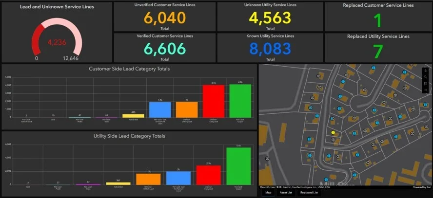
Our most recent success story involves leveraging Esri's Lead Service Line Solution for a City in Massachusetts. Sanborn Geospatial has been working with the city for nearly two decades to develop and maintain valuable data such as utilities, including their water distribution system. We worked with the city to configure a custom Esri ArcGIS Online dashboard, backed by Esri’s Lead Service Line Solution, that visualizes water service line materials throughout the city. This dashboard enables City staff to quickly understand where lead, unknown, and non-lead materials exist within the distribution system and monitor progress as inventory updates and replacement projects occur. In addition, the dashboard provides insight into lead service lines on both the utility side and customer side, helping city staff better understand the scope of work ahead, prioritize future replacement efforts, and report the replacement status to the necessary government agencies.
The project demonstrates the power of combining Sanborn's municipal GIS expertise with Esri's industry-leading technology platforms. By creating a centralized system for managing lead service line information, the city has improved visibility into its infrastructure while establishing a framework that supports ongoing reporting, public communication, and long-term asset management. |
 |
|
Beyond MapGeo |
Many communities know Sanborn through MapGeo and parcel maintenance services, but Sanborn's capabilities extend far beyond online mapping and property data. As a comprehensive geospatial solutions provider, Sanborn combines consulting expertise, advanced content services, custom applications, analytics, imagery, broadband solutions, and enterprise GIS support to help organizations make better decisions with their data. One of Sanborn's greatest strengths is the ability to blend expertise across divisions. Clients can combine MapGeo and parcel data services with aerial imagery, LiDAR, analytics, custom application development, broadband solutions, strategic planning, transportation services, and machine learning initiatives.
As a one-stop geospatial partner, Sanborn offers:
Sincerely,
The Spatial IQ for MapGeo Team at Sanborn Geospatial
P.S. - Interested in having your city or county spotlighted in a MapGeo newsletter? Reply directly to this email to let us know.
Have you checked out our MapGeo Support Portal? Head to the portal for tips, tricks, and ideas on ways to expand your MapGeo and Spatial IQ. |
|
 |
|